My East Tennessee East Tennessee Guides
Home › History › The Lost State of Franklin

East Tennessee history · 1784–1789

The Lost State of Franklin (1784–1789)

For four and a half years, the settlers of upper East Tennessee ran a state of their own: a governor, courts, counties, a capital at Greeneville and a barter economy that set even the governor’s pay in deer skins. Congress never let it in, North Carolina never let it go, and a feud between John Sevier and John Tipton ended in gunfire in the snow.

In short

The State of Franklin was the first serious try at a new state west of the Appalachians after the Revolution. It covered the settled valleys of today’s upper East Tennessee, and it lasted from the summer of 1784 into early 1789. [S6][S1502] Its people held conventions at Jonesborough, made John Sevier their governor, wrote a constitution, set up courts and counties, moved their capital to Greeneville and asked Congress to admit them as a state. [S6][S1500] Congress never did. North Carolina, which still claimed the land, fought the new state with pardons, tax relief and a rival set of courts and officers, and the movement broke apart in a long feud between Sevier and John Tipton. [S6][S1504]

Franklin is often called the "lost" state, and the name fits. Historians still argue over what it was: a democratic frontier revolt, a land speculators’ scheme, or westerners tired of being run from the east. [S1502] On this page we follow it from the land grab of 1783 to Lesser Franklin in 1789, and we show where its counties sit on today’s map. Where the sources disagree on dates or details, we say so and give each version.

A country beyond the mountains

By the early 1780s, thousands of settlers lived along the Watauga, Holston and Nolichucky rivers. The first of them had come in the late 1760s and early 1770s, and in 1772 they had formed the Watauga Association to govern themselves. [S5][S1102] North Carolina later took the settlements in as its Washington District and, in 1777, as Washington County, which at first covered almost all of what would become Tennessee. [S1029] Sullivan County followed in 1779, and Greene County, named for General Nathanael Greene, in 1783. [S1503][S860]

The mountains made all of this hard to govern. The Tennessee Encyclopedia says the distance from the settlements to the seat of government made it hard for lawmakers in the east to understand frontier life, and hard for settlers to get help with their complaints. [S6] The westerners had also just won a war. In 1780, many of them had gathered at Sycamore Shoals under Sevier and others and marched over the mountains to beat the British at Kings Mountain. That victory made Sevier the leading figure among the people beyond the mountains. [S85]

The land grab and the cession

The trouble started with land. Under the Articles of Confederation, Congress had little power to raise money, and the easiest way to fund the new national government was for states to hand over their western lands. North Carolina did not do that at first. In 1783 it reopened its western land office instead, treating the Cherokees as having lost their claims by siding with the British, and put nearly all the land west of the mountains up for sale. [S6]

Insiders knew the act was coming. The encyclopedia says many of the most prominent members of the legislature claimed more than four million acres in what came to be called the "Great Land Grab." [S6] The Tipton-Haynes State Historic Site’s timeline says William Blount led the speculators who helped pass it. [S1500] Once their titles were safe, those same lawmakers backed giving the western lands to Congress. In 1784 North Carolina passed an act ceding its western lands, with the condition that existing land titles would stand. [S6] NCpedia and the Newberry Library’s county chronology date the cession to April 1784, while the Tipton-Haynes timeline and the encyclopedia’s Washington County entry put it in June. [S1502][S1503][S1500][S1029]

The cession left the westerners in an odd place. The Tipton-Haynes timeline says North Carolina gave Congress a year to accept the gift and kept authority over the land until it did. [S1500] To the settlers, it looked as if their state had cut them loose and Congress might not pick them up. [S1029]

Jonesborough, August 1784

Delegates from Washington, Sullivan and Greene counties met at Jonesborough, Tennessee’s oldest town, in late August 1784. [S1502][S1503][S1031] The Tipton-Haynes timeline says two men were chosen from each militia captain’s company, and that the meeting was called because people feared that Congress would turn down the cession and that North Carolina would pay them little attention, leaving the frontier open to lawlessness and Indian war. [S1500] The encyclopedia credits Arthur Campbell of southwestern Virginia and others in the Holston settlements with arranging the meeting. [S6]

The vote for a separate state was unanimous. [S6][S1500] NCpedia says the meeting chose Sevier as its president. [S1502] The Newberry chronology says the delegates were encouraged by the federal Ordinance of 1784, which held out the promise of new states west of the mountains. [S1503] The encyclopedia’s John Sevier entry adds that Thomas Jefferson had proposed carving as many as eighteen new states from the western lands. [S85]

The exact day depends on whom you read. A marker on East Main Street in Jonesborough says Franklin was "organized" there on August 23, 1784. [S1049] The Tipton-Haynes timeline says August 23–24, NCpedia says August 24, and the Newberry chronology dates the meeting to August 31. [S1500][S1502][S1503]

Repeal, and a December declaration

That fall, North Carolina changed its mind. The encyclopedia says anger at the land grab ran so high that voters threw out many of the business-minded lawmakers in the 1784 elections, and the new legislature repealed the cession. [S6] The Tipton-Haynes timeline gives the votes as 37 to 22 in the House of Commons and 19 to 11 in the Senate, and says North Carolina did not think the other states were giving up their own western lands. [S1500] From that moment, the encyclopedia says, the statehood movement was technically a rebellion. [S6]

The western convention met anyway at Jonesborough on December 14, 1784. [S6][S1500] Because news traveled slowly, NCpedia says, the delegates did not know the cession had been repealed in November. [S1502] They declared independence from North Carolina and adopted a temporary constitution, borrowing North Carolina’s own with changes such as lowering or dropping the property requirements for holding office. [S6][S1502] The Tipton-Haynes timeline says the vote was 28 to 15, with John Tipton and Joseph Tipton of Washington County voting no. [S1500] The Newberry chronology dates the proclamation to December 17. [S1503]

Franklin never drew exact borders. NCpedia says the December constitution implied a claim to all of the ceded land, roughly the future state of Tennessee, and that some leaders hoped to add parts of western Virginia and northern Georgia. [S1502] The Newberry chronology says that in practice the new state took in the settled parts of present East Tennessee. [S1503] The settlers on the Cumberland in Middle Tennessee, on lands set aside for North Carolina’s Revolutionary War soldiers, stayed out of it. [S1502]

Frankland or Franklin?

The name took a while to settle. The encyclopedia’s entry on Arthur Campbell says Campbell wanted a larger state called "Frankland" that would take in parts of western North Carolina, southwestern Virginia and Kentucky. Sevier preferred "Franklin" and a state limited to western North Carolina, and the Jonesborough delegates went with Sevier’s smaller plan. [S1506] Virginia later brought charges of treason against Campbell; they were dropped, but he lost his post as a justice of the peace in Washington County, Virginia, in 1786. [S1506]

The Tipton-Haynes timeline says Franklin’s commissioner William Cocke wrote to Benjamin Franklin in 1786 to tell him the state had been named for him. Franklin answered that he had understood the name was Frankland and wished the new state well. [S1500] A "Frankland Constitution" also turned up at the second constitutional convention, as we explain below. [S1500]

Governor Sevier and the first assembly

Sevier did not start out as a rebel. The Tipton-Haynes timeline cites a January 1785 letter in which he welcomed command of North Carolina’s new Washington District brigade, and says he told crowds in Jonesborough and Greene County about North Carolina’s conciliatory offers and urged them to go no further. [S1500] In a March 1788 letter he said he had been "dragged" into the Franklin measures. [S1500]

He went along all the same. Franklin’s first General Assembly met at Jonesborough in March 1785 and, according to NCpedia and the Tipton-Haynes timeline, elected Sevier governor. [S1502][S1500] The encyclopedia’s Franklin entry tells it differently, placing Sevier’s election, the barter system and the four new counties at a third convention held "the following March," after a November 1785 convention. [S6] Both versions agree that Sevier, the hero of Kings Mountain, became Franklin’s first and only governor. [S85]

The assembly recognized the three old counties, Washington, Sullivan and Greene, and made new ones. [S1503] Landon Carter of the Watauga settlements became Speaker of the Senate and later Franklin’s secretary of state. [S1505] When North Carolina’s governor, Alexander Martin, sent Major Samuel Henderson to ask what the westerners were doing, the assembly answered on March 22 that the people of Franklin wished to be separate. [S1500] On April 25 Martin issued a manifesto against the "revolting" state, and Sevier answered with a proclamation of his own. [S1500] The Sevier entry quotes Martin’s threat to "render the revolting territory not worth possessing." [S85]

Franklin’s new counties

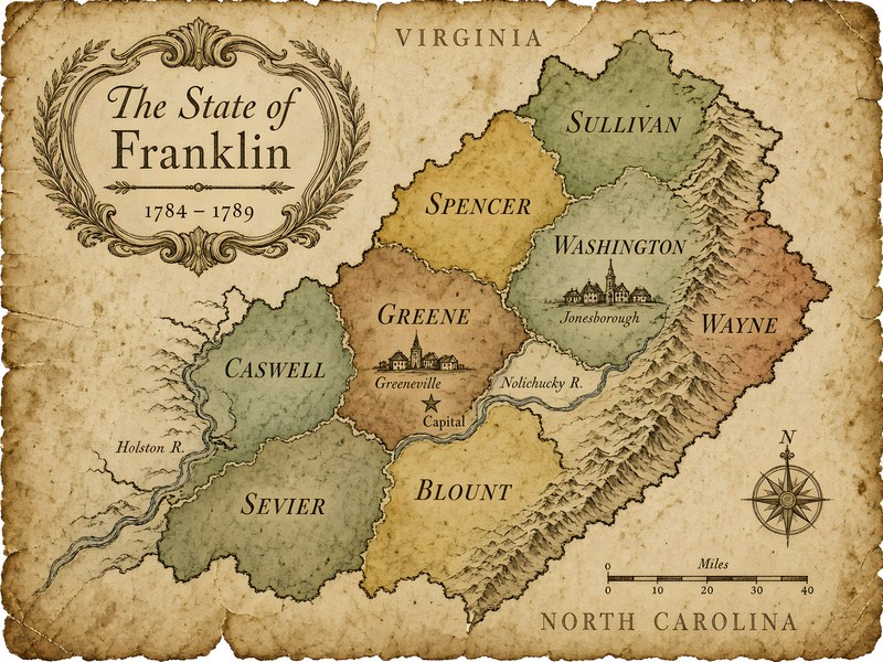
Franklin’s assembly made four new counties in March 1785, and a fifth appears later that year. The texts of the acts have not survived, and the exact boundaries are unknown. [S1503] North Carolina never recognized any of them. [S1503] Here is where they were:

Spencer County’s militia shows how thin Franklin’s hold became. In March 1788 William Cocke ordered it raised against Tipton, and the Tipton-Haynes timeline says the orders went unheeded, probably because many of its captains refused. [S1500]

Antique parchment-style map of the State of Franklin, 1784–1789, showing Sullivan, Spencer, Washington, Wayne, Greene, Caswell, Sevier and Blount counties with Jonesborough and Greeneville.
Map: original AI-assisted artwork by My East TN. Decorative, not survey-accurate: Franklin’s county lines were never recorded, so the shapes and placements are artistic. Use the table above, not this map, for where each county lay.

Asking Congress

Franklin did not mean to stay independent. It wanted to join the Union as a new state. The first assembly sent a memorial to Congress asking for admission and named William Cocke its commissioner. [S1502][S1500] The Tipton-Haynes timeline says Cocke reached New York, where Congress was meeting, on May 15, 1785, and spoke to it the next day, and that Congress turned the new state down. [S1500]

What Congress actually voted on is easy to misstate. NCpedia says a motion to approve North Carolina’s cession, which would have opened the way to statehood, fell short of the nine votes required. [S1502] Under the Articles of Confederation, nine of the thirteen states, about two-thirds, had to agree. Many retellings say seven states voted in favor. We could not check that tally against the congressional record this week, so we leave it as unconfirmed.

There was a longer-lasting result. NCpedia notes that the fight over Franklin came just as the new federal Constitution was being drafted, and Article IV of that Constitution says no new state can be formed within another state’s jurisdiction without that state’s consent. [S1502]

Greeneville and the constitution fight

Jonesborough was Franklin’s first capital, and the encyclopedia dates its time as capital to 1784–85. [S1031] Franklin’s government then moved to Greeneville. [S6][S1500] The Tipton-Haynes timeline says Greeneville became the "permanent and only" capital at the November 1785 constitutional convention. [S1500] A state marker on North College Street in Greeneville stands beside a replica of the building believed to have served as Franklin’s capitol from 1785 until 1788, which originally stood near Main and Depot streets. [S876]

The November 1785 convention was a bitter one. The marker says competing plans produced the first political pamphlets printed west of the Appalachians, with three Presbyterian ministers, Samuel Houston, William Graham and Hezekiah Balch, leading the fight. [S876] Houston’s proposed "Frankland Constitution" would have set up a one-house legislature with property, religious and moral tests for its members. [S1500][S6] The delegates turned it down in favor of a plan much like North Carolina’s. [S1500] John and Joseph Tipton and seventeen others protested the vote. [S1500] The encyclopedia’s Greene County entry calls this convention the split that brought on Franklin’s end. [S860]

The Franklin legislature also met in Greeneville. The marker says it challenged North Carolina by passing laws to levy taxes, raise a militia, set up courts, authorize marriages and open a land office. [S876]

Taxes in skins and linen

Franklin leaned on barter. The encyclopedia says the new state set up a barter system for paying taxes. [S6] Franklin’s assembly even paid its officials in kind. The Tipton-Haynes timeline says that in October 1788 the assembly decided Sevier would be paid 1,000 deer skins for his time as governor. [S1500]

North Carolina saw its chance in the taxes. The encyclopedia says North Carolina offered pardons and forgave two years of back taxes to anyone who returned to its side. [S6] The Shelby–Sevier agreement of March 1787, discussed below, even let settlers pay their taxes to either government. [S1502]

Dumplin Creek, Hopewell and Coyatee

Most of the land Franklin wanted belonged to the Cherokees, and NCpedia says Franklin’s short history is largely a story of Indian war and attempts to take Indian land. [S1502] On June 10, 1785, at Henry’s Station near the mouth of Dumplin Creek, close to today’s Kodak, Sevier and Franklin’s commissioners signed a treaty with a group of Cherokee leaders led by Ancoo of Chota. [S91][S115] It was the only treaty Franklin ever made. It opened land south of the French Broad and Holston rivers, inside the reservation North Carolina had set aside for the Cherokees; NCpedia says the ceded tract included the site of Greeneville. [S91][S1502] The encyclopedia says only a token number of Cherokee chiefs signed it. [S6]

Congress had its own plans. On November 28, 1785, United States commissioners and a much larger Cherokee delegation signed the Treaty of Hopewell in South Carolina. [S1507] The encyclopedia says it drew a line north of Greeneville, and NCpedia says it cancelled the Dumplin Creek treaty. [S6][S1502] The Tipton-Haynes timeline says the Hopewell line left parts of Franklin’s Greene, Spencer, Blount, Caswell and Sevier counties on the Cherokee side. [S1500] Franklinites took Hopewell as proof that Congress would not defend them. Settlers kept moving onto the disputed land, and the two treaties led to open war between Franklin and the Cherokees. [S6][S1507]

By August 1786 the Cherokees had been forced to sign the Treaty of Coyatee, which the encyclopedia says allowed settlement as far south as the Little Tennessee River. [S6] The Tipton-Haynes timeline dates the talks to July 31 through August 3, 1786, with William Cocke leading the Franklin side. [S1500] In this period, the encyclopedia says, Franklin’s hard line toward the Cherokees won it strong support among settlers south of the French Broad, who were most exposed to attack. [S6]

Two governments in one valley

From 1786 on, two governments claimed the same people. North Carolina named its own officers in the west, created new courts and counties, and organized a militia brigade, first with Sevier as its brigadier general. [S6] In August 1786 John Tipton won election to the North Carolina Senate for Washington County. The two sides even held separate elections, the Franklinites in Jonesborough and North Carolina’s supporters near Sycamore Shoals. [S1500]

North Carolina then created Hawkins County on top of Franklin’s Spencer County. [S606][S1503] It appointed Evan Shelby brigadier general for the western counties and made Tipton colonel of the Washington County militia. [S1500] The Tipton-Haynes timeline calls 1787 a year of "courthouse wars." Rival courts met in the same counties, and each side raided the other’s court records and sometimes tried to take them back. [S1500] In March 1787 Franklin’s assembly made it a crime to act as an officer under North Carolina and hanged Tipton in effigy. [S1500]

Shelby and Sevier tried to keep the peace. In March 1787 they met in Sullivan County and agreed that settlers could pay taxes to either government. [S1502][S1500] Neither side kept the agreement for long. [S1500] In August 1787 the Franklin assembly elected Shelby to succeed Sevier as governor, and Shelby turned it down. [S1502] Under North Carolina’s new governor, Richard Caswell, the state kept to a soft line. When Shelby asked for a thousand North Carolina troops in May 1787, Caswell refused to send them. [S1502][S1500]

Franklin’s own support was fading. Late in 1787 a petition asking North Carolina to let Franklin go, signed by, among others, Archibald Roane and Andrew Jackson, was read in the North Carolina assembly and ignored. [S1500] That fall a bill to undo the 1784 repeal narrowly passed both houses before protests got it tabled. [S1500]

Sevier and Tipton

The fight over Franklin turned personal. John Tipton, born in Maryland in 1730, had served in the Virginia legislature and moved to present Tennessee in 1782. [S1504] He bought land in 1784 at the site that is now the Tipton-Haynes State Historic Site in Johnson City and built a log house there. [S1037] The encyclopedia’s Tipton entry says he backed statehood at first, to protect his own land claims and those of his friends, but split the movement in his feud with Sevier. [S1504]

When North Carolina demanded in 1785 that the westerners give up the new state, Tipton promised his loyalty. Sevier did not, and instead demanded loyalty to Franklin. [S1504] The two men also disagreed over the constitution, and in 1786 they came to blows over which laws governed the Washington County militia, which Tipton commanded. [S1504] The Tipton-Haynes timeline says that after the November 1785 convention, the two met in a Jonesborough street, where Sevier hit Tipton over the head with a cane and Tipton fought back with his fists before they were pulled apart. [S1500] The encyclopedia’s Washington County entry calls their rivalry long-lived and bitter. [S1029]

The Battle of the State of Franklin

The feud came to a head in February 1788. On orders from North Carolina’s Washington County court, Sheriff Jonathan Pugh seized property from Sevier, including several enslaved people, to cover taxes the court said he owed, and took them to Tipton’s house for "safe keeping." [S1051][S1501] According to oral history, they were held in the cabin’s basement kitchen. [S1052]

Sevier raised a force of Franklin militia in Greeneville and, on February 27, 1788, surrounded Tipton’s cabin with more than 100 men. [S1051][S1501] Tipton ignored a demand to surrender within thirty minutes. The next day he answered a second flag by saying that all he wanted was submission to North Carolina’s laws. [S1501] Sevier chose to wait outside rather than storm the house. [S1501] During the siege, the Tipton-Haynes site says, Franklin sentries fired on a relief company, and a young woman passing near Tipton’s still house was shot through the shoulder. [S1501]

Help reached Tipton in the snow. Major Robert Love slipped a small party past the Franklin pickets, and early on February 29 Colonel George Maxwell’s Sullivan County militia came up in a heavy snowstorm. [S1501][S1051] Shooting broke out, Tipton led his men out of the cabin, and after about ten minutes Sevier’s men fell back to Jonesborough. [S1501][S1051] The Tipton-Haynes site quotes a loyalist, Dr. Taylor, who said neither side really wanted to kill the other and that some men did not even load their guns. [S1501]

People still died. The state marker at Tipton-Haynes says three men were mortally wounded, Sheriff Pugh among them. [S1051] The site’s Tipton history says two were North Carolina loyalists and one a Franklinite. [S1501] The encyclopedia’s Tipton entry names Pugh and John Webb as the dead and says two of Sevier’s sons were captured and later released. [S1504] The encyclopedia calls the fight the "Battle of the Lost State of Franklin" and says it marked Franklin’s end. [S1037] Sevier’s term as governor ran out on March 1, 1788, and no one replaced him. [S1502][S1500] Two days later he signed a letter to Tipton only as president of the Franklin council. [S1501]

The Tipton cabin itself raises a newer question. A 2008 tree-ring study by the University of Tennessee dated logs in the house to 1795–99, which suggests the cabin may have been rebuilt to about the same size before 1800. [S1052]

Spain, the arrest and Morganton

With Congress closed to them, some Franklin leaders looked elsewhere. The encyclopedia says Franklinites opened talks with Spanish authorities about the chance of joining Spain, and the talks came to nothing. [S6] The Tipton-Haynes timeline places the most serious talks, between Sevier and the Spanish minister Diego de Gardoqui, between July and September 1788. [S1500] Sevier also led Franklin forces against the Cherokees and Creeks through the spring and summer of 1788. [S1500]

North Carolina finally moved against him. On July 29, 1788, the encyclopedia’s Tipton entry says, Governor Samuel Johnston ordered Sevier’s arrest for treason, citing an unauthorized attack on Cherokee towns. [S1504] On October 10, after Sevier drew his pistols in a quarrel at a Jonesborough store, a party including Tipton and Major Love found him at a house nearby, and Love made the arrest. [S1500][S1504] Tipton had Sevier put in irons and sent to Morganton, North Carolina, for trial. [S1500][S1504]

The trial never happened. The Tipton-Haynes timeline and the encyclopedia’s Tipton entry say friends and Sevier’s sons came to Morganton and took him home, and the timeline adds that the local sheriff, a Kings Mountain veteran, did not chase them. [S1500][S1504] The encyclopedia’s Franklin entry says Sevier made bail and the new governor quietly ignored the case. [S6] Either way, the Sevier entry says, he was charged with treason but never tried. [S85]

Lesser Franklin and the end

Franklin’s last stand came in the land it had taken by treaty. Settlers south of the French Broad held their land titles from Franklin, under the Dumplin Creek treaty, and had the most to lose. [S1502] In January 1789 they drew up "Articles of Association" and asked North Carolina for protection. [S1502][S1500] A state marker at Newell’s Station near Seymour says the articles were adopted there, and that Newell’s Station served as the seat of government for these "South-of-French-Broad-and-Holston" people from 1789 to 1791. [S1508] The encyclopedia calls their association "Lesser Franklin," and says it faded when no strong leader came forward to replace Sevier. [S6]

Sevier made his own peace. In February 1789 he took an oath of allegiance to North Carolina in a Greene County court. [S1500][S1502] The Newberry chronology dates his oath to February 1, 1789, and treats it as the end of all five Franklin counties. [S1503] That August, Greene County sent him to the North Carolina Senate, and North Carolina made him a brigadier general again. [S1500][S6][S85]

What Franklin left behind

The problem Franklin tried to solve was settled within a few years. North Carolina ceded its western lands to the federal government again in December 1789, and this time Congress accepted; the Newberry chronology dates the transfer to April 2, 1790. [S85][S1501][S1503] In May 1790 Congress created the Territory South of the River Ohio, the Southwest Territory, and President George Washington made William Blount its governor. [S1501][S85] Sevier served on the territory’s legislative council, and when Tennessee became the sixteenth state in 1796, he was elected its first governor. He went on to serve six terms. [S85] Tipton served in the territorial legislature and at the 1796 constitutional convention, and the feud between the two men lasted into statehood. [S1037][S1504]

Franklin’s names are still on the map. Sevier County and its seat, Sevierville, are named for the governor. [S34] Carter County, created in 1796, is named for Landon Carter, Franklin’s Speaker of the Senate and secretary of state. [S1102][S1505] Today’s Blount County is named for the land speculator turned territorial governor whose name Franklin had already given to one of its own counties. [S35][S1500][S1503] The fight Franklin started over the Cherokee lands south of the French Broad went on for years, through the Treaty of Holston in 1791 and beyond. [S1507]

The argument over Franklin continues too. NCpedia says it is still debated whether Franklin began as a democratic movement in the West, as a conspiracy of land speculators, or as a separatist movement led by westerners who resented having their interests put below those of eastern North Carolina. [S1502]

Where Franklin’s counties went

Franklin’s counties did not survive, but their ground did. The boundaries were never recorded, so this table is a rough guide to today’s counties, not a survey.

Franklin countyMade fromRoughly today
Washington (kept)North Carolina county of 1777Washington County, plus land later given to Carter, Johnson and other counties [S1503][S1029]
Sullivan (kept)North Carolina county of 1779Sullivan County [S1503]
Greene (kept)North Carolina county of 1783Greene County [S1503][S860]
Spencer (1785)Greene and SullivanHawkins County [S1503][S606]
Caswell (1785)GreeneJefferson and Hamblen counties [S1503][S720]
Sevier (1785)GreeneSevier County, created again in 1794 [S1503][S34]
Wayne (1785)Washington and Wilkes, N.C.Carter and Johnson counties [S1503]
Blount (by late 1785)GreeneNear today’s Blount County, created in 1795 [S1503]

Where the sources disagree

Franklin’s records are thin, and even good sources disagree. We have given each version on the page. Here are the main conflicts in one place:

Plan a Franklin history day

Most of Franklin’s ground is a short drive apart in the Tri-Cities and the Nolichucky valley. A day might include:

Visit: For hours and directions, check each site’s own page before you go. Our county guides for Washington, Greene, Sullivan and Sevier counties list places and local news.

Timeline

YearWhat happened
1772Watauga settlers form the Watauga Association [S5][S1102]
1777North Carolina creates Washington County [S1029]
1783North Carolina’s "Great Land Grab" land act; Greene County created [S6][S860]
1784North Carolina cedes its western lands (April or June); Jonesborough meeting votes for a new state (August); North Carolina repeals the cession (fall); Franklin declared at Jonesborough (December 14) [S1502][S1500][S6]
1785First assembly elects Sevier governor and creates Spencer, Caswell, Sevier and Wayne counties (March); William Cocke goes to Congress (May); Treaty of Dumplin Creek (June 10); Greeneville constitutional convention (November); Treaty of Hopewell (November 28) [S1502][S1500][S1503][S91][S1507]
1786Treaty of Coyatee (August); Tipton elected to the North Carolina Senate; North Carolina moves to create Hawkins County [S6][S1500]
1787Hawkins County created, January 6; courthouse wars; Shelby–Sevier agreement (March) [S606][S1500][S1502]
1788Battle of the State of Franklin at Tipton’s farm (February 27–29); Sevier’s term ends (March 1); Sevier arrested (October 10) [S1051][S1502][S1504]
1789Lesser Franklin’s Articles of Association (January); Sevier swears allegiance to North Carolina (February); North Carolina cedes its western lands again (December) [S1502][S1508][S1503][S85]
1790Congress creates the Southwest Territory, with William Blount as governor [S1501][S85]
1796Tennessee becomes the sixteenth state, with John Sevier as its first governor [S85]

Keep exploring

Sources

Every bracketed number on this page links here. Written by My East TN in our own words and checked against each source on 2026-10-31 (ET). Where sources disagree, we say so on the page and give each version: the date of the first Jonesborough meeting (August 23, 1784, on the Jonesborough marker; August 23–24 in the Tipton-Haynes timeline; August 24 in NCpedia; August 31 in the Newberry Library chronology); when North Carolina passed its cession act (April 1784 in NCpedia and the Newberry chronology, June 1784 in the Tipton-Haynes timeline and the encyclopedia’s Washington County entry); whether the December convention met on December 14 (the encyclopedia and the Tipton-Haynes timeline) or the state was proclaimed December 17 (Newberry); whether Sevier was first chosen governor in March 1785 (NCpedia and the Tipton-Haynes timeline) or at a convention the encyclopedia’s Franklin entry places the following March; the vote in Congress, where NCpedia says the motion fell short of the nine states required and retellings often give seven states in favor, a tally we could not check against the congressional record this week; whether Blount County, State of Franklin, was formed in August 1785 (the Tipton-Haynes timeline and, as a probability, Newberry) and whether it was ever fully organized; when Franklin’s Caswell County began (1784 in the encyclopedia’s Jefferson County entry, March 1785 in Newberry); whether Hawkins County dates from November 1786 (when the Tipton-Haynes timeline puts the North Carolina session) or January 6, 1787 (the encyclopedia and Newberry), which our Hawkins County history already flags; who died at the Battle of the State of Franklin (three men, two loyalists and one Franklinite, in the Tipton-Haynes accounts and the state marker; Sheriff Pugh and John Webb in the encyclopedia’s John Tipton entry); and how Sevier’s 1788 arrest ended (rescued from Morganton by friends and sons in the Tipton-Haynes and encyclopedia Tipton accounts; released on bail and the case ignored in the encyclopedia’s Franklin entry). We don’t republish encyclopedia, museum or marker text — follow the links for the full articles.

  1. S5 Watauga Association ↗ — W. Calvin Dickinson · Tennessee Encyclopedia (Tennessee Historical Society)
  2. S6 State of Franklin ↗ — Michael Toomey · Tennessee Encyclopedia (Tennessee Historical Society)
  3. S34 Sevier County ↗ — Beulah Duggan Linn · Tennessee Encyclopedia (Tennessee Historical Society)
  4. S35 Blount County ↗ — Tara Mitchell Mielnik · Tennessee Encyclopedia (Tennessee Historical Society)
  5. S85 John Sevier ↗ — Robert E. Corlew · Tennessee Encyclopedia (Tennessee Historical Society)
  6. S91 "Dumplin Creek Treaty" marker (THC 1C 5), Kodak ↗ — THC marker text · hmdb.org
  7. S115 "Treaty of Dumplin Creek" marker (THC), Kodak ↗ — THC marker text · hmdb.org
  8. S606 Hawkins County ↗ — Henry R. Price · Tennessee Encyclopedia (Tennessee Historical Society)
  9. S720 Jefferson County ↗ — Estle P. Muncy · Tennessee Encyclopedia (Tennessee Historical Society)
  10. S860 Greene County ↗ — Blythe Semmer · Tennessee Encyclopedia (Tennessee Historical Society)
  11. S876 "Capitol of State of Franklin" marker (THC 1C 70), Greeneville ↗ — THC marker text · hmdb.org
  12. S1029 Washington County ↗ — Mildred S. Kozsuch and Ruth Broyles · Tennessee Encyclopedia (Tennessee Historical Society)
  13. S1031 Jonesborough ↗ — Carroll Van West · Tennessee Encyclopedia (Tennessee Historical Society)
  14. S1037 Tipton-Haynes Historic Site ↗ — Kenneth Fields · Tennessee Encyclopedia (Tennessee Historical Society)
  15. S1049 "State of Franklin" marker, Jonesborough ↗ — Marker text · hmdb.org
  16. S1050 Tipton-Haynes State Historic Site ↗ — Tennessee Historical Commission · tn.gov/historicalcommission
  17. S1051 "Battle of the State of Franklin" panel, Tipton-Haynes ↗ — THC marker text · hmdb.org
  18. S1052 "Colonel Tipton Cabin" panel, Tipton-Haynes ↗ — THC marker text · hmdb.org
  19. S1102 Carter County ↗ — Carroll Van West · Tennessee Encyclopedia (Tennessee Historical Society)
  20. S1500 The State of Franklin (year-by-year timeline, 1783–1789) ↗ — Tipton-Haynes State Historic Site (Tipton-Haynes Historical Association) · tipton-haynes.org
  21. S1501 Colonel John Tipton (including the Battle of the State of Franklin, 1788) ↗ — Tipton-Haynes State Historic Site (Tipton-Haynes Historical Association) · tipton-haynes.org
  22. S1502 State of Franklin ↗ — George W. Troxler, from the Encyclopedia of North Carolina (2006) · NCpedia (State Library of North Carolina)
  23. S1503 Tennessee: Consolidated Chronology of State and County Boundaries ↗ — John H. Long, ed., and Peggy Tuck Sinko · Atlas of Historical County Boundaries, The Newberry Library
  24. S1504 Tipton, John ↗ — Carroll Van West · Tennessee Encyclopedia (Tennessee Historical Society)
  25. S1505 Landon Carter ↗ — W. Calvin Dickinson · Tennessee Encyclopedia (Tennessee Historical Society)
  26. S1506 Arthur Campbell ↗ — Tara Mitchell Mielnik · Tennessee Encyclopedia (Tennessee Historical Society)
  27. S1507 Treaties ↗ — Fred S. Rolater · Tennessee Encyclopedia (Tennessee Historical Society)
  28. S1508 "Newell's Station" marker (THC 1C 3), Chapman Highway, Seymour ↗ — THC marker text · hmdb.org

Hero and map art: an original antique parchment-style map of the State of Franklin, created with AI assistance and finished by My East TN. It is a stylized, decorative map, not a historical document or a survey: Franklin’s county lines were never recorded, so county shapes and positions are artistic, and it is not copied from any period map. It is not an official image of the Tipton-Haynes State Historic Site, the Tennessee Historical Commission, the Tennessee Historical Society, NCpedia, the Newberry Library or any other source on this page, and no endorsement by any of them is implied. Reused source numbers (S5, S6, S34, S35, S85, S91, S115, S606, S720, S860, S876, S1029, S1031, S1037, S1049, S1050, S1051, S1052, S1102) match the same sources on our other history pages. Corrections: [email protected].